Earthquake Prevention Related to Sewage Infrastructure
Due to its tectonic situation, the Basel region is at increased risk of earthquakes, which is particularly relevant for critical sewage infrastructure. The AUG was commissioned by the Basel-Landschaft Office for Industrial Operations to systematically analyze and spatially represent potential earthquake-related hazards to the sewage infrastructure in a pilot area (Figure).
The aim of the study is to create a technically sound basis for decision-making on preventive measures, prioritization of measures and further detailed investigations. The study focuses on both direct earthquake effects such as ground movements and vibration amplification, as well as indirect, so-called secondary effects, including landslides, ground subsidence and interactions with hydrogeological conditions. The study has a modular structure and combines existing cantonal data with current geological models of the AUG. This structured approach allows all types of hazards relevant to the sewage infrastructure to be taken into account.
Particular focus is placed on spatially linking the identified hazards with existing pipelines, structures and facilities. Among others, active and potentially active faults (Figure), transitions between solid and soft subsoil conditions, known hazard zones for mass movements and areas with a potential risk of ground settlement or soil liquefaction are analyzed. In addition, results from earthquake microzonation and building ground class maps were used to assess the expected intensity of ground vibrations on a regional basis.
The key result is a summary hazard map for the pilot area, which provides a quick overview of potentially affected infrastructure elements. This map is not intended to replace object-specific evidence, but rather serves as a strategic tool for identifying critical sections at an early stage and initiating targeted in-depth investigations or structural measures. The study thus makes an important contribution to the protection of water bodies and groundwater and to ensuring the operability of the wastewater infrastructure in the event of an incident.
In addition, the investigations are intended to show that the methodological approach developed can in principle be transferred to other parts of the canton and to municipal infrastructure in general. The results thus form a reliable basis for the gradual canton-wide implementation of earthquake prevention in the area of sewage infrastructure and support the canton of Basel-Landschaft in forward-looking, risk-based infrastructure planning.
Commissioned by: AIB BL
Project duration: 2025 – 2026
Brian Steiner, Horst Dresmann & Jannis Epting
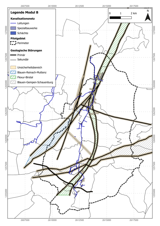
Figure: Sewage infrastructure in relation to potential underground movements along faults, derived from 3D geological modelling. Faults are classified as primary faults (length > 5 km, with the potential to cause earthquakes independently) and secondary faults (length < 5 km, closely related to primary faults in terms of structure and origin).
Quick Links
Social Media