Prof. Dr. P. Huggenberger, C. Regli
Overview
GEOSSAV is a tool for the integration of hard and soft data into the stochastic simulation and visualization of distributions of geological structures and hydrogeological properties in the subsurface. As an interface to selected geostatistical modules from the Geostatistical Software LIBrary, GEOSSAV can be used for data analysis, variogram computation of regularly or irregularly spaced data, and sequential indicator simulation of subsurface heterogeneities. Sequential indicator simulation, based on various kriging techniques, is suitable for the simulation of continuous variables such as hydraulic conductivity of an aquifer or chemical concentrations at a contaminated site, and categorical variables, which indicate the presence or absence of a particular lithofacies.
GEOSSAV can be used whenever stochastic solutions are preferred to solve site-specific heterogeneity problems, e.g., in the field of hydrology, groundwater, groundwater and/or soil contamination, site remediation, air pollution, and ecology. Subsequent modeling is external to GEOSSAV.
SNF: 2100-049272
Background
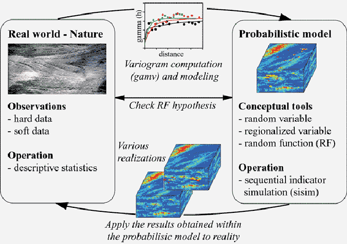
Stochastic simulation is the process of drawing multiple, equally probable realizations of random variables from a random function model. The realizations represent possible images of spatial distributions of the data values over a field. Each realization reflects the spatial properties that have been imposed on the random function model. The more properties are inferred from the sample data and integrated in the random function model through the simulation algorithm, the higher the accuracy will be of the random function model and the resultant simulated realizations in representing the heterogeneity of the spatial phenomenon.
Conceptual framework of stochastic simulation
Based on the variogram computation of the hard input data and the following stochastic simulation, e.g., sequential indicator simulation, various equally probable realizations are generated, which represent images of the reality. The simulation is conditional if the resulting realizations honor data values at their locations. The various realizations have to reproduce the input proportions within a defined accuracy. Accepted realizations should be applied to reality to compare measured and calculated data.
Integration platform and modules
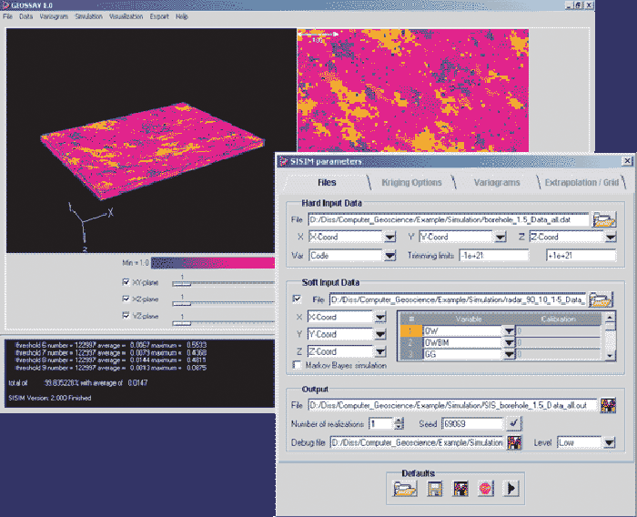
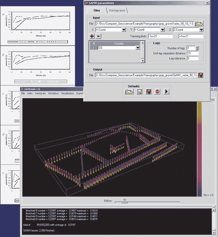
The software integration platform and development environment of GEOSSAV is Tcl with its graphical user interface, Tk, and a number of Tcl/Tk extensions. Compiled GSLIB modules (Deutsch and Journel, 1998) without any enhancements are integrated into GEOSSAV: The sequential indicator simulation module 'sisim' requires information about the spatial variability of the regularly or irregularly spaced data, which can be computed with the variogram module 'gamv' and then visualized with the module 'vargplt' and a PostScript display device. The indicator kriging approach allows the modeling of single property classes, represented by indicators, using single indicator variograms. In addition, the sisim algorithm is able to account for soft data. The integration of soft data in the indicator formalism is made possible by the Markov-Bayes option for cokriging using the module 'bicalib'.
The standard OpenGL API is used for rendering 3D data distributions and for slicing perpendicular to the main coordinate axis. Export options for finite-difference groundwater models allow either files that characterize single model layers or files that characterize the complete 3D flow model set-up for MODFLOW-based groundwater simulation systems.
When selecting a module from the pull-down menus, a corresponding dialog box for parameter input is opened. The dialog box is designed to require the input of all options, which are necessary for running the module.
Example
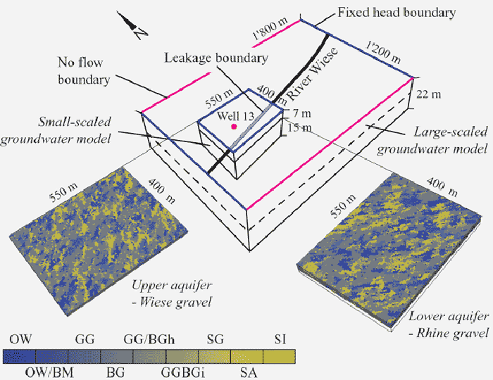
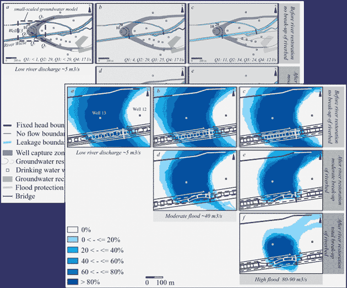
GEOSSAV was applied to generate the aquifer structures of a well capture zone (in the order of several hundred of meters). The main outcome of the variogram analysis is the orientation of the sedimentary structure types representing the main flow direction of the river Rhine in the lower part of the aquifer and the tributary Wiese in the upper part of the aquifer.
The aquifer structures were simulated on a 550 m x 400 m x 22 m grid and subsequently exported to an external finite-difference groundwater model (PMWIN from Chiang and Kinzelbach, 2001) to simulate flow and advective transport. The deterministic, large-scaled groundwater model (1.8 km x 1.2 km x 22 m) is used to simulate the average behavior of groundwater flow and transport. It is also used to assign the boundary conditions for the small-scaled groundwater model, which relies on stochastically generated aquifer properties based on site-specific drill-core and georadar data. The small-scaled groundwater model is used to include the large subsurface heterogeneity at the location of interest.
Results
The groundwater models includes simulation of changing well capture zones depending on subsurface heterogeneity, hydrologic variations, water supply operation data, and progress of river restoration. The stochastic approach in the small-scaled groundwater model does not lead to a clearly defined well capture zone, but to a plane representation of the probability of a certain surface location belonging to the well capture zone. The models were applied to a study site, which is located in an area of artificial groundwater recharge and production, in Lange Erlen near Basel, Northwestern Switzerland.
Download
The download includes everything needed to run GEOSSAV including the current version of GEOSSAV and all the necessary open-source Tcl/Tk interactive-environment software. Although the authors Ch. Regli, L. Rosenthaler, and P. Huggenberger cannot provide any professional support service, they welcome comments and will attempt to respond to questions regarding the software and its application. The authors neither guarantee the integrity nor the proper performance of the software. The development of GEOSSAV was financially supported by the Swiss National Science Foundation.
GEOSSAV 1.0 for Windows
Windows installation of GEOSSAV
1. download geossav1.0.zip
2. extract geossav1.0.zip in C:\ (and refresh the MS Windows Explorer)
3. set the system variable (path) C:\Programme\Tcl8.4\bin
4. create a shortcut of geossav.exe on the desktop (can be found in C:\geossav)
Now you can run GEOSSAV