Geological 3D-models – NW Switzerland at various scales
Horst Dresmann
For more than 20 years, the AUG has been developing geological 3D-models which can be employed as tools for dealing with many issues in the areas of groundwater, geothermal energy, infrastructure planning and civil engineering (Figures 1-3).
Sound geological knowledge and modeling experience form the basis for the development of geological 3D-models, which can consistently map complicated geological layering and structural conditions. Together with Geographical Information Systems GIS and groundwater models, ideal conditions for quantitative hydrogeological investigations can be created.
In addition to the geological 3D-model for the Basel region (20 x 30 km) (Figure 1), in scope of numerous research projects the AUG has created local- and, in cooperation with project partners, regional-scale geological 3D-models (Figures 2 & 3).
![[Translate to English:] 3dmodel](https://duw.unibas.ch/fileadmin/_processed_/c/b/csm_Flyer_3_3D_Modell_gesamt_af8987d61e.png?1614891524)
Figure 1: Geological 3D model of the Basel region
![[Translate to English:] 3dmsl](https://duw.unibas.ch/fileadmin/_processed_/3/b/csm_3DM_Schichtlagerung_all_9084dddb97.jpg?1614891523)
![[Translate to English:] 3dmslsat](https://duw.unibas.ch/fileadmin/_processed_/d/d/csm_3DM_Schichtlagerung_all_mitSAT_a3df5132b9.jpg?1614891523)
Figure 2 a&b: Geological 3D-model of the area around Belchenfluh (Scheidler, S. et al. 2019, model extraction 4 km x 4 km x 2 km)
Scheidler, S. et al. (2019) “Tools to simulate changes in hydraulic flow systems in complex geologic settings affected by tunnel excavation”, Bulletin of engineering geology and the environment, 78(2), pp. 969–980. Available at: 10.1007/s10064-017-1113-5.
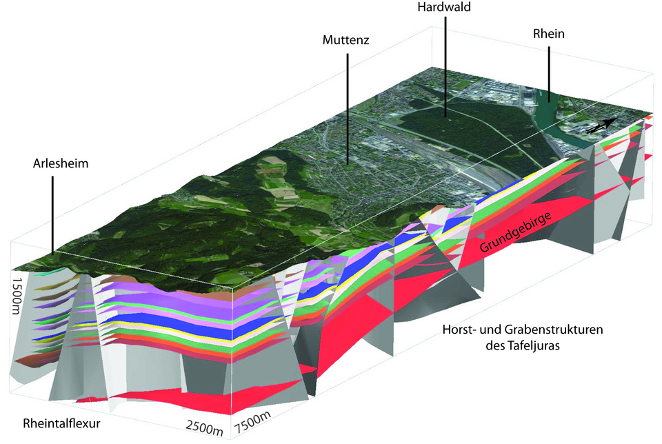
Figure 3: 3D-detail view for the area of Muttenz - Arlesheim, extracted from the geological 3D-model of the Basel region (Figure 1)
Quick Links
Social Media