Subrosion - Instruments for the sustainable management of active and ancient salt mining areas
Eric Zechner
Funded by the Swiss National Science Foundation and the Romanian Executive Agency for Higher Education, Research, Development and Innovation Funding within the framework of the Romanian-Swiss Research Programme (RSRP, Grant IZERZ0_142147)
The objectives of the 3-year Swiss-Romanian project were to develop tools that allow the representation and efficient use of 3D geological and hydrogeological information in active or abandoned salt mining areas. The tools form the basis to face problems related to land subsidence and aquifer contamination, and to develop sustainable development strategies for mining areas. The Ocna Mureş mining area in Transylvania, which is continuously facing environmental problems such as surface collapse, land subsidence, and surface water and aquifer contamination from brines, is ideally suited to serve as an example for the approach. Rock salt of the near-surface diapir in Ocna Mures has been explored since the Roman ages in open excavations, and up to the 20th century in galleries and with solution mining. Most recently, in 2010 a sudden collapse in the adjacent Quaternary unconsolidated sediments led to the formation of a 70-90 m wide salt lake with a max. depth of 23 m.
Five tasks have been proposed and were carried out in the project: (1) the development of an adaptive data-management system, (2) the collection of geophysical and hydrogeological data in the Ocna Mureş mining perimeter, (3) the development of a geological 3D model of the mining area, (4) numerical flow and transport modeling for scenario development, and (5) the integrative evaluation of the hazards in the Ocna Mureş mining area.
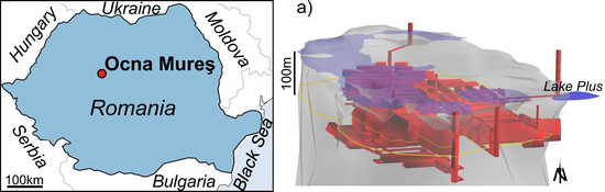
Figure: Left: Location of the town Ocna Mureş (Romania), which was built around the diapir; Right: 3D model view of the upper part of the Ocna Mureş salt dome (grey) and the mining galleries (red), the lakes (light blue, except Lake Plus in blue (Zechner et al. 2019).
Zechner, E., Dresmann, H., Mocuţa, M., Danchiv, A., Huggenberger, P., Scheidler, S., Wiesmeier, S., Popa, I. and Zlibut, A. (2019) “Salt dissolution potential estimated from two-dimensional vertical thermohaline flow and transport modeling along a Transylvanian salt diapir, Romania”, Hydrogeology journal. Springer, 27, pp. 1245–1256. doi: 10.1007/s10040-018-1912-1.
Subrosion of evaporitic rocks
Eric Zechner
Evaporites of gypsum and of rock salt are widely regarded as the most soluble rock formations. Subsaturated groundwater in contact with evaporitic rock formations leads to subsurface dissolution of evaporites, also named subrosion. The resulting karst may develop rapidly, e.g. for rock salt within a few years, months, or even shorter periods of time. Depending on the hydrogeological setting, such as depth of the karst, character of flow paths, and mechanical properties of overlaying sediments, subrosion may cause widespread land subsidence or collapsing. In addition, leakage of the dense salt brine out of the karstified host formation can contaminate aquifers and surface water bodies by resulting variable-density flow.
AUG has been conducting research on causes and mechanisms of subrosion for more than 15 years. Research focus is on structural characterization of evaporitic rock formations with geological 3D models, amongst others, the genesis and shapes of salt and gypsum solution cavities, and on theoretical and experimental work on density-driven flow of brines. The research results have been applied to study sites in Northwestern Switzerland and in Transylvania, Romania.
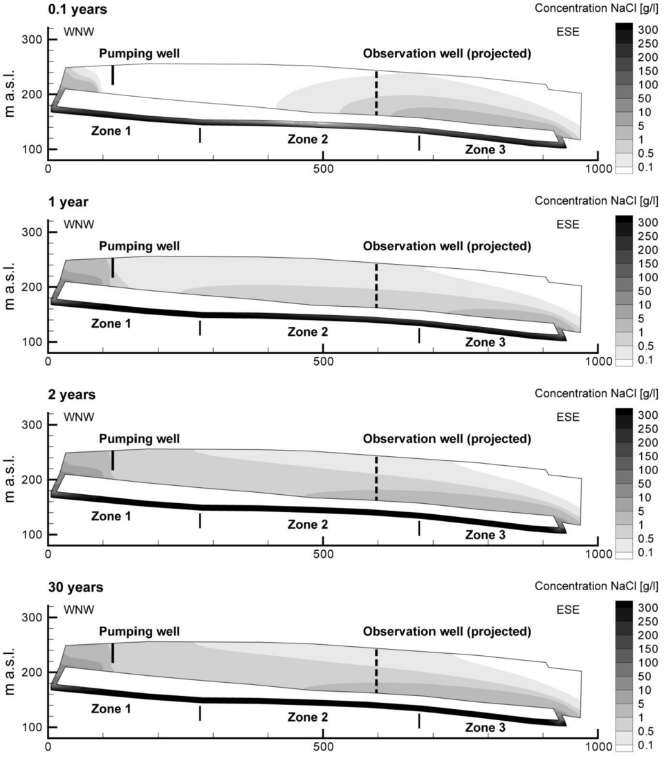
Figure: Simulated evolution of density-coupled upward flow of brines (NaCl) into surficial aquifer model from Tabular Jura in “Muttenz-Pratteln” area (Zechner E., Konz M., Younes A., Huggenberger P., 2011: Effects of tectonic structures, salt solution mining, and density-driven groundwater hydraulics on evaporite dissolution (Switzerland), Hydrogeology J., 7, 1323-1334, https://doi.org/10.1007/s10040-011-0759-5 ).
Quick Links
Social Media