Subrosion - Instruments for the sustainable management of active and ancient salt mining areas
[Nur auf Englisch]
Eric Zechner
Funded by the Swiss National Science Foundation and the Romanian Executive Agency for Higher Education, Research, Development and Innovation Funding within the framework of the Romanian-Swiss Research Programme (RSRP, Grant IZERZ0_142147)
The objectives of the 3-year Swiss-Romanian project were to develop tools that allow the representation and efficient use of 3D geological and hydrogeological information in active or abandoned salt mining areas. The tools form the basis to face problems related to land subsidence and aquifer contamination, and to develop sustainable development strategies for mining areas. The Ocna Mureş mining area in Transylvania, which is continuously facing environmental problems such as surface collapse, land subsidence, and surface water and aquifer contamination from brines, is ideally suited to serve as an example for the approach. Rock salt of the near-surface diapir in Ocna Mures has been explored since the Roman ages in open excavations, and up to the 20th century in galleries and with solution mining. Most recently, in 2010 a sudden collapse in the adjacent Quaternary unconsolidated sediments led to the formation of a 70-90 m wide salt lake with a max. depth of 23 m.
Five tasks have been proposed and were carried out in the project: (1) the development of an adaptive data-management system, (2) the collection of geophysical and hydrogeological data in the Ocna Mureş mining perimeter, (3) the development of a geological 3D model of the mining area, (4) numerical flow and transport modeling for scenario development, and (5) the integrative evaluation of the hazards in the Ocna Mureş mining area.
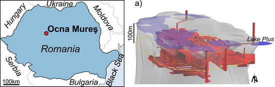
Figure: Left: Location of the town Ocna Mureş (Romania), which was built around the diapir; Right: 3D model view of the upper part of the Ocna Mureş salt dome (grey) and the mining galleries (red), the lakes (light blue, except Lake Plus in blue (Zechner et al. 2019).
Zechner, E., Dresmann, H., Mocuţa, M., Danchiv, A., Huggenberger, P., Scheidler, S., Wiesmeier, S., Popa, I. and Zlibut, A. (2019) “Salt dissolution potential estimated from two-dimensional vertical thermohaline flow and transport modeling along a Transylvanian salt diapir, Romania”, Hydrogeology journal. Springer, 27, pp. 1245–1256. doi: 10.1007/s10040-018-1912-1.
Subrosion von Evaporit-Gesteinen
Eric Zechner
Evaporite wie Gips/Anhydrit und Steinsalz gehören zu den leichtlöslichen Gesteinen, d.h. bei Kontakt von untersättigtem Grundwasser mit den Evaporiten kann es zu unterirdischer Lösung kommen, auch Subrosion genannt. Der sich dabei bildende Karst kann sich im Fall von Steinsalz innerhalb von Monaten bis wenigen Jahren vergleichsweise schnell entwickeln. Hydrogeologische Rahmenbedingungen wie Formationstiefe, Beschaffenheit der Grundwasserzutrittspfade und mechanische Eigenschaften der überlagernden Gesteine sind ebenfalls entscheidend bei der möglichen Entstehung von grossflächiger Subsidenz und Einbrüchen an der Erdoberfläche. Des Weitern können die entstehenden salinaren Wässer beim Austritt aus dem Evaporit-Karst benachbarte Grundwasserträger kontaminieren.
Die Fachgruppe AUG betreibt die Forschung zu den Ursachen und Mechanismen der Subrosion seit 15 Jahren. Schwerpunkte sind dabei die strukturelle Charakterisierung der Evaporitgesteine u.a. mit geologischen 3D Modellen, die Entstehung und Form von Lösungskavernen und theoretische und experimentelle Modelle zur dichtegekoppelten Strömung von salinaren Grundwässern. Die Forschungsergebnisse wurden bisher mit Feldbeobachtungen im Untersuchungsgebiet der Nordwestschweiz (Muttenz-Pratteln) und in Transsylvanien, Rumänien, verglichen.
Abbildung: Simulation des zeitlichen Ablaufs von dichtegekoppeltem Aufstieg salinarer (NaCl) Grundwässer in oberflächennahem Aquifer am Beispiel eines Querschnitts durch den Tafeljura bei Muttenz-Pratteln (Zechner E., Konz M., Younes A., Huggenberger P., 2011: Effects of tectonic structures, salt solution mining, and density-driven groundwater hydraulics on evaporite dissolution (Switzerland), Hydrogeology J., 7, 1323-1334, https://doi.org/10.1007/s10040-011-0759-5 ).
Quick Links
Social Media